
If you are searching for the best Pag Island map, you probably want more than a simple road map.
You want to know where to swim, where to eat, which villages are worth exploring, where to watch the sunset, where the most spectacular viewpoints are and which places most visitors never discover.
That is exactly what this guide is designed to provide.
Pag is one of Croatia’s most distinctive islands. Its landscape changes dramatically as you travel from south to north: quiet fishing settlements give way to historic Pag Town, salt pans and sheep pastures; the central island reveals traditional cheese-making villages; and farther north, the scenery becomes increasingly dramatic around Novalja, Caska, Metajna and the rocky landscapes associated with the famous Life on Mars trail.
This Pag Island map brings all of those experiences together.
Instead of showing only the biggest tourist attractions, we have selected 50 locations that help explain the real character of Pag: villages, beaches, natural landmarks, archaeological sites, viewpoints, local food producers and restaurants.
Whether you are visiting Pag for one day, a week or an entire summer, bookmark this guide and use it as your starting point for exploring the island.
Quick answer: The places we consider essential for a first visit to Pag are Pag Town, Novalja, Lun, Metajna, Ručica Beach, Beritnica Beach, Zrće Beach, Caska, Sveti Vid, the Life on Mars landscape, the Lun Olive Gardens, Pag’s salt pans, Kolan and at least one traditional Pag cheese dairy.
Ultimate Pag Island Travel Guide
Interactive Pag Island Map
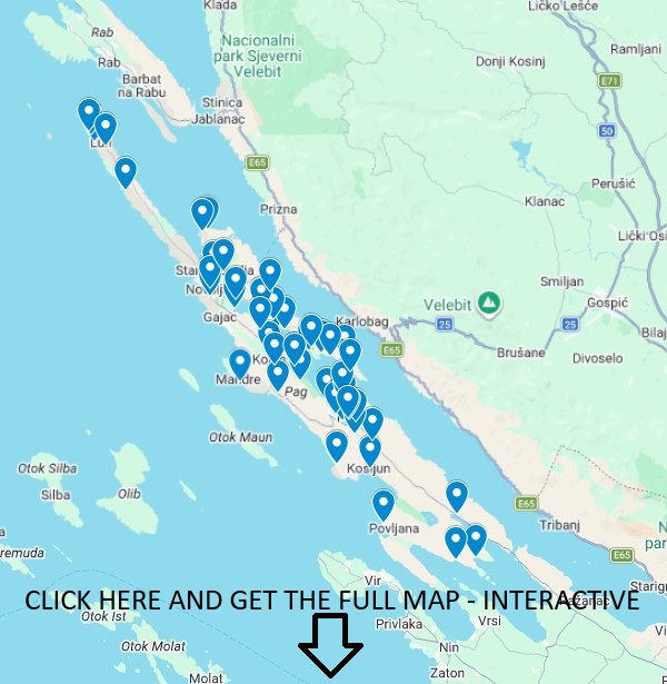
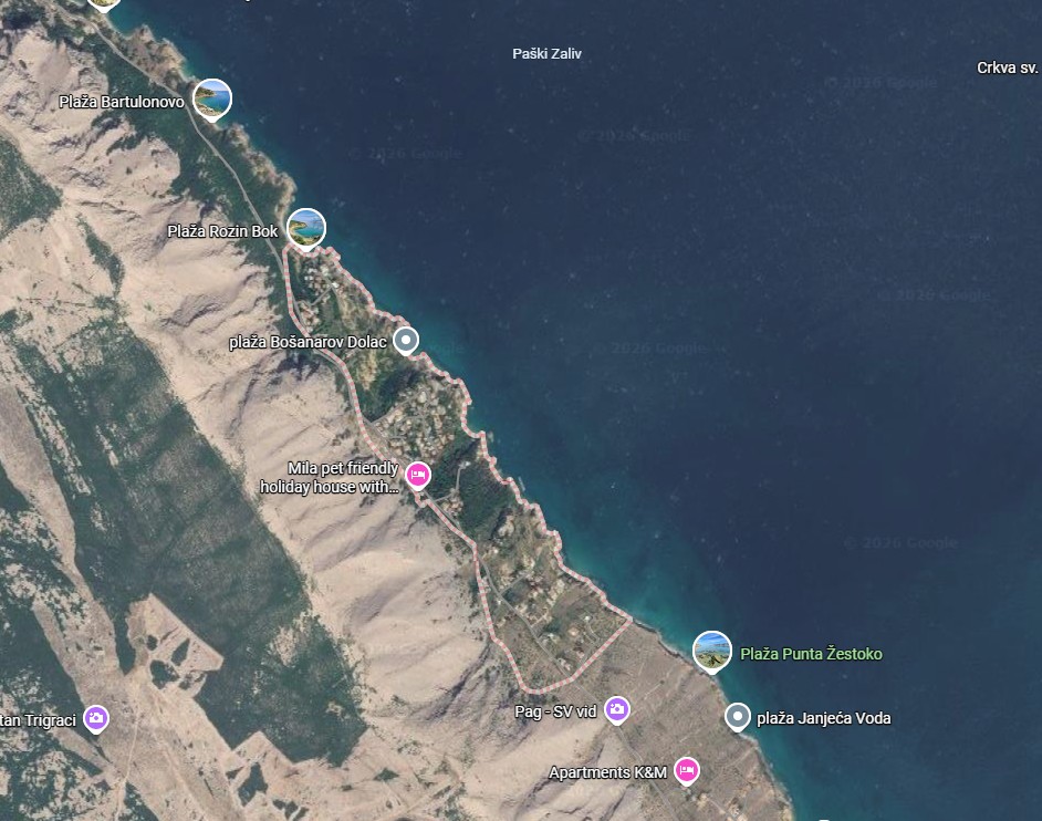
Explore our interactive Pag Island map with beaches, villages, viewpoints, restaurants, attractions and hidden gems across the island. Click the image to open the full interactive map.
INTERACTIVE MAP HERE: “Pag Island Map – 50 Best Places”
For the best user experience, we have divided the map pins into five categories:
- Blue: beaches and swimming
- Red: towns and villages
- Green: nature and viewpoints
- Purple: culture and history
- Orange: restaurants, cheese dairies and gastronomy
Visitors should be able to click every pin and see for example:
|
Address
|
Lokunje Beach, Novalja, Croatia
|
|
Icon Style
|
Beach / swimming
|
|
Original Category
|
Town beach
|
|
Map Group
|
North Pag
|
|
Category Color
|
Blue
|
This turns a simple travel article into an interactive Pag Island travel database.
Pag Island Map at a Glance: All 50 Places
Towns, villages and coastal areas – Pag island map
- Pag Town
- Novalja
- Lun
- Metajna
- Zubovići
- Kustići
- Vidalići
- Kolan
- Mandre
- Šimuni
- Povljana
- Dinjiška
- Vlašići
- Smokvica
- Proboj
- Sv. Marko
- Bošana
- Košljun
- Stara Novalja
- Jakišnica and Tovarnele
Beaches – Pag island map
- Ručica Beach
- Beritnica Beach
- Zrće Beach
- Sveti Duh Beach
- Caska Beach
- Prosika Beach
- Vodice Beaches
- Bašaca Beach
- Planjka–Trinćel Beach
- Jadra Beach
- Čista Beach
- Lokunje Beach
- Mata Cove
- Veli Bok
- Slana Beach
- Malin Beach
Nature, viewpoints, history and unusual places – Pag island map
- Sveti Vid
- Life on Mars Trail
- Lun Olive Gardens
- Pag Salt Pans
- Old Town of Pag
- Gradac Viewpoint
- Talijanova Buža Roman Aqueduct
- Pag Triangle
Pag gastronomy – Pag island map
- Sirana Gligora
- Paška Sirana
- Sirana MIH
- Boškinac Restaurant
- Bistro Na Tale
- Trapula Wine & Cheese Bar
1. Pag Town – The Historic Heart of the Island
Map category: Town & culture
Best for: history, restaurants, evening walks, families
Allow: half a day to one full day
Pag Town deserves to be one of the first pins on any serious map of Pag Island.
Unlike destinations built mainly around tourism, Pag has an identity that stretches far beyond beaches. Its historic centre is a compact network of pale stone streets, squares, churches and traditional architecture, with the distinctive landscape of the Pag salt pans immediately beside it.
The town was planned in the 15th century and contains several important historic landmarks, including the Church of the Assumption of the Blessed Virgin Mary, Rector’s Palace, Skrivanat Tower and remnants of the old defensive system.
Yet Pag is not a museum.
Walk through town in the evening and terraces fill, fishing boats move through the bay and families stroll along the waterfront. It remains one of the best places on the island to experience the combination of everyday island life and tourism.
Pag Town should also be your introduction to three things that define the island:
Pag lace. Pag salt. Pag cheese.
Try local cheese, walk through the historic centre, visit the waterfront and then continue toward the salt landscape south of town.
Don’t miss: the main square after sunset.
ApartmentPag tip: Visit the old centre in late afternoon, stay for dinner and walk along the waterfront after dark.
2. Novalja – Pag’s Energetic Northern Centre
Map category: Town
Best for: nightlife, restaurants, shopping, excursions
Allow: half a day or an evening
Novalja is Pag’s second major urban centre and has a completely different personality from Pag Town.
Where Pag is historic and traditional, Novalja feels energetic, international and contemporary.
Its waterfront is busy during summer, with restaurants, bars, excursion boats, shops and a constant flow of visitors heading toward nearby beaches.
It is also the main gateway to Zrće Beach, but reducing Novalja to nightlife would be a mistake.
The town has significant Roman heritage, family beaches, a promenade and easy access to some of northern Pag’s most interesting places.
Most importantly for travellers using this Pag Island map, Novalja makes an excellent base for exploring:
- Lun;
- Stara Novalja;
- Caska;
- Zrće;
- Vidalići;
- Zubovići;
- Kustići;
- Metajna.
3. Lun – Ancient Olive Country at the End of Pag
Drive almost as far north as Pag allows and the island begins to change.
Around Lun, the barren stone landscape gives way to an extraordinary world of olive trees, dry-stone walls and quiet settlements.
Lun is one of the places where you should stop thinking in terms of beaches and start simply walking.
The internationally significant Olive Gardens of Lun are nearby and contain a remarkable population of wild and cultivated olive trees. The Novalja Tourist Board describes approximately 80,000 olive trees across the wider landscape and notes the protected botanical importance of the area.
Come during the cooler morning or late afternoon and allow yourself time to explore without rushing.
Best for: nature lovers, photographers, slow travel and couples.
4. Metajna – Gateway to Pag’s Most Dramatic Landscape
If one area explains why Pag is often compared to another planet, it is Metajna.
The small coastal village sits beneath an immense wall of pale stone and gives access to Ručica Beach, Beritnica and the landscapes used by the Life on Mars trail.
Metajna itself is attractive, but its real significance on a Pag Island map is geographical.
This is your gateway into one of Croatia’s most unusual coastal environments.
Come early in the morning if you intend to hike.
Bring proper footwear, water and sun protection because much of the surrounding landscape has almost no natural shade.
5. Zubovići – Stone Village Above the Sea
Zubovići is one of four settlements commonly associated with the Barbati area along Pag Bay.
Set slightly above the coast, it offers expansive views toward the sea and the Velebit mountains across the channel.
The atmosphere is noticeably calmer than Novalja.
This makes Zubovići particularly attractive for travellers who want easy access to northern Pag’s major attractions without staying in the busiest resort zones.
From here you can quickly explore:
Caska → Vidalići → Kustići → Zubovići → Metajna → Ručica → Beritnica.
It is one of the most rewarding mini-road-trips on the island.
6. Kustići – Quiet Pag by the Water
Continue along the coast and you reach Kustići, a small village where the pace becomes noticeably slower.
The Novalja Tourist Board describes Kustići around its local food, fresh fish, small coves and peaceful island atmosphere.
That is exactly its appeal.
There is no single gigantic attraction here.
Instead, Kustići is about terraces overlooking the sea, morning swims, small beaches, local restaurants and evenings when the light changes over the bay.
For visitors who want to experience a more residential side of Pag, it deserves its place on the map.
7. Vidalići – Peace Close to the Action
Vidalići proves how quickly the personality of Pag can change.
You are close to Novalja and Zrće, yet the waterfront atmosphere feels completely different.
Small beaches, private apartments and views across Pag Bay make it particularly attractive for couples and families.
Its strategic location also makes Vidalići a useful base for discovering:
- Caska;
- Zrće;
- Zubovići;
- Kustići;
- Metajna;
- Ručica.
For photographers, the Velebit mountains across the channel can create extraordinary backgrounds when visibility is good.
8. Kolan – The Capital of Pag Cheese Country
If Pag Town represents the island’s salt tradition, Kolan represents cheese.
The village lies in the central part of the island surrounded by pastures shaped by stone, wind, aromatic plants and sheep farming.
For food travellers, Kolan is absolutely essential.
This is where you will find Sirana Gligora and Sirana MIH, making Kolan one of the best places to learn why Paški sir – Pag cheese – became one of Croatia’s most famous gastronomic products.
Do not simply drive through.
Stop, taste several ages of cheese and compare them.
Then look at the landscape around you.
The connection between the product and the island becomes much easier to understand.
9. Mandre – Relaxed Seaside Village
Mandre occupies the western side of the island and looks toward the islands scattered beyond Pag.
Its waterfront atmosphere makes it an excellent evening stop.
Restaurants and cafés sit close to the sea while small beaches extend along the settlement.
Mandre works particularly well for travellers looking for somewhere between the two extremes of Pag tourism:
not isolated,
but not intensely urban either.
Come for an afternoon swim and stay for sunset.
10. Šimuni – Fishing Village Between Pag and Novalja
Šimuni occupies an almost perfect position roughly between Pag Town and Novalja.
The official Pag tourism guide describes it as a fishing village on the south-western coast particularly suited to family holidays, walking and swimming.
Its small harbour filled with boats immediately gives Šimuni a different atmosphere from many modern resorts.
It is particularly pleasant around sunset.
If you are travelling between Pag and Novalja, don’t simply pass it on the main road.
Turn toward the sea.
11. Povljana – Family-Friendly Southern Pag
Povljana feels greener and gentler than many of the stark landscapes found farther north.
It has long been popular with families thanks to its accessible beaches, relatively relaxed atmosphere and position in the southern part of Pag.
If you are visiting with young children or simply prefer a traditional beach holiday, Povljana belongs on your itinerary.
It also makes an interesting contrast with Metajna.
Visit both and you will understand just how diverse one island can be.
12. Dinjiška – Pag Beyond the Main Tourist Route
Dinjiška sits on southern Pag in a shallow bay.
The Pag Tourist Board describes the village as a picturesque southern settlement surrounded by secluded beaches and notes the remains of an old salt-production facility from the period of French administration.
Most visitors rush north toward Pag Town and Novalja.
That is precisely why Dinjiška is interesting.
Come here when you want to see another face of Pag.
13. Vlašići – A Different Kind of Pag Beach Holiday
Vlašići is another southern village well suited to families.
Its calm bay and combination of sand and pebbles contrast beautifully with the harder rocky shores elsewhere on the island.
The Pag Tourist Board highlights Vlašići as a peaceful destination with a strong agricultural tradition and local Pag cheese, lamb and wine.
If your image of Pag is entirely white rock and party beaches, Vlašići will change it.
14. Smokvica – Small, Quiet and Almost Hidden
Smokvica sits close to Vlašići and is one of the quieter pins on this Pag Island map.
The official tourism description is refreshingly simple: a small settlement above a long beach, suited to travellers looking for peace, clean sea and quiet surroundings.
That is exactly why we include it.
Not every destination needs attractions.
Sometimes the attraction is the absence of them.
15. Proboj – Pag for Travellers Seeking Silence
Proboj is one of southern Pag’s most peaceful coastal settlements.
The Pag Tourist Board describes it as a small destination for family holidays where fishing, sheep farming and traditional foods remain part of local identity.
ApartmentPag knows this area especially well.
The coastline around Proboj is ideal for travellers who prioritise:
- silence;
- uncrowded swimming;
- sea views;
- local atmosphere;
- privacy;
- sunsets;
- slower holidays.
It offers the opposite experience to Zrće—and that contrast is exactly what makes Pag so unusual.
16. Sv. Marko – Quiet Views Across Pag Bay
Sv. Marko is another place that receives far less attention than Pag Town, Novalja or Metajna.
That makes it valuable.
The landscape is open and exposed, with powerful views toward the sea and the mountain backdrop beyond the island.
For photographers and travellers searching for privacy rather than infrastructure, the wider Sv. Marko area deserves a pin.
It is also an area where ApartmentPag can add something competitors cannot easily copy: original first-hand photography, seasonal observations and local knowledge.
17. Bošana – Stone, Sea and Wild Pag
Drive north from Pag Town toward the western coastline and Bošana quickly reveals why the island’s scenery feels so distinctive.
The beaches around Bošana are known for unusually clear water and a stark relationship between white limestone and blue sea.
Freshwater springs in the area can make the sea feel cooler, and protected woodland occurs nearby at Sveta Marija and Dubrava.
This is excellent territory for swimming, photography and simply driving slowly along the coast.
18. Košljun – A Small Harbour Away From Everything
Košljun is another southern Pag destination worth discovering if you are intentionally avoiding the busiest parts of the island.
The Pag Tourist Board describes it as a small harbour in a naturally sheltered bay with a simple, authentic atmosphere and beaches suited to families.
Its sheltered position gives it a completely different feeling from Pag’s exposed eastern side.
19. Stara Novalja – The Quieter Side of Novalja
Stara Novalja stretches around a long sheltered bay north of modern Novalja.
It is especially attractive for travellers who want to remain close to Novalja’s services while sleeping somewhere calmer.
Beaches, diving and family accommodation dominate the area rather than nightlife.
It is also close to Planjka–Trinćel, one of northern Pag’s popular family beaches.
20. Jakišnica and Tovarnele – The Road Toward Lun
As you travel toward the northern tip of Pag, the settlements become smaller and the journey itself becomes part of the attraction.
Jakišnica and nearby Tovarnele are worth adding to your Pag Island map as stops on the way to Lun.
The scenery combines stone walls, olive trees, small harbours and a noticeably slower rhythm.
Don’t drive straight through.
Stop for coffee or lunch and let northern Pag unfold gradually.
THE BEST BEACHES ON THE PAG ISLAND MAP – Pag island map
The island offers dramatically different beaches within relatively short driving distances.
Some are ideal for young children.
Others require hiking shoes.
Some are surrounded by restaurants and facilities.
Others have almost nothing except stone and sea.
That diversity is one reason Pag deserves much more than a single beach day.
The official tourism material lists numerous sandy, pebble and rocky beaches across the island, including Bošana, Sveti Duh, Zrće, Caska, Ručica, Slana, Malin and others.
21. Ručica Beach – One of Pag’s Essential Beaches – Pag island map
Best for: scenery, swimming, photography
Natural shade: very limited
Facilities: limited
Location: near Metajna
Ručica is not beautiful in a conventional Mediterranean way.
There are no rows of pine trees framing the beach.
Instead, immense bare slopes descend toward blue water.
That is what makes it extraordinary.
The Novalja Tourist Board describes Ručica as a mixture of shingle and sand approximately one kilometre from Metajna, accessible by road or boat and surrounded by the distinctive Canyon landscape.
Come early.
In peak summer the temperature can become intense and shade is scarce.
If you are creating only one photograph for your Pag Island guide, Ručica should be a serious candidate.
[INTERNAL LINK: Ručica Beach complete guide]
22. Beritnica Beach – Pag at Its Most Cinematic – Pag island map
Walk beyond Ručica through Pag’s lunar terrain and eventually you reach Beritnica, also written Beriknica.
Three enormous rocks rising from the shallow sea make the beach immediately recognisable.
The official Novalja tourism guide notes that Beritnica has no natural shade or significant amenities and is reached by sea or by walking through the dramatic surrounding landscape.
That lack of infrastructure is part of the appeal.
Beritnica feels elemental:
rock + sea + sky.
Bring everything you need and take everything away with you.
[INTERNAL LINK: Beritnica Beach guide]
23. Zrće Beach – Pag’s Most Famous Beach – Pag island map
Whether you love nightlife or avoid it completely, Zrće belongs on any complete Pag Island map.
It is internationally famous for large open-air clubs, festivals and summer nightlife.
During the day, however, Zrće is still a broad pebble beach where visitors swim, eat and participate in water activities.
The Pag Tourist Board describes the beach as one centred around all-day entertainment, with venues operating through the day and into the night.
Visit once simply to understand the phenomenon.
Then decide whether your Pag experience needs another night there—or a quiet sunset in Proboj.
24. Sveti Duh Beach – Open Space and Pag Bay Views – Pag island map
Sveti Duh lies along the coast between Pag and the northern settlements.
The attraction here is space.
Open views across Pag Bay and the surrounding barren slopes create the quintessential Pag combination of stone and enormous sky.
It is an excellent stop during a coastal driving day that includes:
Pag → Bošana → Sveti Duh → Caska → Metajna.
25. Caska Beach – Swim Above Roman History – Pag island map
Caska is unusual because the story continues beneath the water.
The beach occupies the site of an ancient Roman settlement, and archaeological remains have been identified around the bay and seabed.
The Novalja Tourist Board describes Caska as the site of a former Roman settlement and notes that archaeological traces remain close to the beach and underwater.
The entrance to the sea can be relatively gentle before the seabed becomes deeper.
Combine Caska with Zrće because the two beaches are geographically close but historically worlds apart.
26. Prosika Beach – Pag Town’s Family Beach – Pag island map
You do not need to leave Pag Town to swim.
Prosika is the town’s central beach and one of the easiest choices for families staying nearby.
The official tourism board specifically identifies Prosika as suitable for families with small children and notes the availability of recreational and hospitality facilities.
Its convenience is its greatest advantage.
Swim in the morning, walk back into Pag for lunch and explore the old centre in the afternoon.
27. Vodice Beaches – Small Coves North of Pag – Pag island map
Vodice is less about one single spectacular beach and more about a sequence of rocky shoreline and smaller pebble coves.
The Pag Tourist Board describes the area as having both rocky and pebble sections, with some smaller coves harder to access.
This makes Vodice particularly interesting if you enjoy searching for your own swimming spot rather than arriving at a large organised beach.
28. Bašaca Beach – Convenient Swimming Near Pag – Pag island map
Bašaca lies immediately north of Pag Town.
Several smaller beaches are spread along the shoreline, and road access is relatively straightforward.
The official tourism board specifically notes Bašaca’s easy access thanks to the road following the coast.
It is therefore an excellent choice for a spontaneous swim without turning the entire day into an excursion.
29. Planjka–Trinćel – Family Swimming Near Stara Novalja – Pag island map
Planjka–Trinćel is one of the most familiar beach names around Stara Novalja.
Its relatively gentle entry into the water and developed summer infrastructure make it especially popular with families.
If your Pag itinerary includes small children, place it alongside Prosika and Povljana on your shortlist rather than focusing only on dramatic beaches like Beritnica.
30. Jadra Beach – Rocky Northern Pag – Pag island map
Near Stara Novalja, Jadra offers a different experience again.
The Novalja Tourist Board describes sections with fine stones and gradual sea access together with rockier sections that enter deeper water more quickly.
It is a useful reminder that even individual beaches on Pag can change character within a relatively short distance.
31. Čista Beach – Big Views Across Pag Bay – Pag island map
Čista is popular because it combines accessible swimming with expansive views across the wide bay.
The landscape is classic Pag:
pale rock,
low vegetation,
transparent water,
and Velebit rising across the channel.
It works well as part of a northern beach-hopping day between Novalja and Metajna.
32. Lokunje Beach – Swimming in Novalja – Pag island map
Lokunje is Novalja’s town beach.
The Novalja Tourist Board describes it as a shallow pebble beach along the southern edge of Novalja Bay with a substantial green belt behind it.
That makes it convenient for travellers who want a simple swim without driving.
It is not the island’s wildest beach—and that is exactly the point.
33. Mata Cove – Olive Trees Meet the Sea – Pag island map
Around Lun, beaches begin to feel very different from Metajna’s barren landscape.
Mata Cove combines small swimming areas with the ancient olive landscape of northern Pag.
The Novalja Tourist Board specifically describes Mata as a quiet bay with hidden beaches and coves surrounded by old olive trees.
For travellers who have already visited Beritnica and Ručica, Mata provides a beautiful visual contrast.
34. Veli Bok – A Wilder Side of Pag – Pag island map
Veli Bok belongs to the less-developed category of Pag beaches.
It is a location for travellers who value scenery and quiet more than cafés, loungers and organised activities.
Treat places like this with respect.
Bring sufficient water, avoid damaging vegetation and leave absolutely nothing behind.
35. Slana Beach – Raw Pag Landscape – Pag island map
Slana appears among the notable beaches listed in Pag tourism materials.
Its appeal lies in the surrounding rocky scenery rather than resort infrastructure.
This is a place for people who deliberately seek Pag’s raw side.
It also fits naturally into a future ApartmentPag article targeting hidden beaches on Pag Island.
[INTERNAL LINK: Hidden Beaches of Pag]
36. Malin Beach – For Pag Explorers – Pag island map
Malin is another name worth adding to a more complete map rather than limiting your itinerary to the handful of beaches everyone already knows.
It appears in official Pag beach listings and belongs to the island’s more adventurous coastal landscape.
For experienced Pag visitors, searching out places like Malin is often where the island becomes most rewarding.
NATURE, HIKING, HISTORY AND VIEWPOINTS ON PAG
Pag is much more than a beach destination.
In fact, some of the island’s most memorable experiences do not involve swimming at all.
The next eight locations reveal Pag’s geology, history and strange beauty.
37. Sveti Vid – The Highest Point of Pag Island
Elevation: 348 m
Best for: hiking, panoramic views, photography
Best time: morning or late afternoon
Sveti Vid is the highest point on Pag Island at 348 metres above sea level. A small medieval church dedicated to St Vitus stands near the summit.
The number may not sound impressive compared with mainland Croatian mountains.
But altitude tells only part of the story.
Pag is long, narrow and surrounded by sea, so the elevated position creates a spectacular visual relationship between land, islands, mountains and water.
From above, the island’s geography finally makes sense.
This is one of the best places to understand Pag rather than merely visit it.
Avoid the middle of extremely hot summer days.
[INTERNAL LINK: Sveti Vid Pag hiking guide]
38. Life on Mars Trail – Pag’s Otherworldly Side
Few Croatian trail names are as appropriate as Life on Mars.
The landscape around Metajna has almost no visual connection with the stereotypical Mediterranean image of pine forests and green islands.
Instead you encounter bare rock, steep slopes, exposed coastline and immense open views.
The trail network has become one of the island’s defining outdoor experiences and is associated with organised trail events as well as independent hiking.
This location deserves its own major ApartmentPag guide eventually, including:
- route options;
- map;
- GPX data;
- difficulty;
- distance;
- elevation;
- water advice;
- parking;
- photography points;
- safety information.
Do not underestimate the heat.
Pag’s exposed rock reflects sunlight and much of this landscape offers very little shade.
[INTERNAL LINK: Life on Mars Pag complete guide]
39. Lun Olive Gardens – One of Pag’s Great Natural Treasures
The Olive Gardens of Lun deserve more than a quick photograph.
The protected landscape at the northern end of Pag contains an extraordinary concentration of ancient olive trees growing among traditional dry-stone walls.
According to the Novalja Tourist Board, around 80,000 olive trees occur across the broader landscape, while part of the area containing wild olive trees has protected botanical status.
Walk slowly.
Look at how the trunks twist around stone.
Notice how little soil seems to exist.
Then remember that people have cultivated this harsh landscape for generations.
It is one of the places where Pag’s relationship between humans and nature becomes most visible.
40. Pag Salt Pans – The Landscape That Helped Build Pag
Salt is not merely a souvenir from Pag.
It is part of the island’s economic and cultural history.
The salt pans stretch across a large flat landscape south-east of Pag Town and form one of the island’s most recognisable man-made environments.
The Pag Tourist Board notes that Pag’s salt pans are among the oldest documented on the eastern Adriatic and that the modern Solana Pag production landscape covers around two million square metres.
The old salt warehouses opposite the historic centre provide another visible connection to this industry.
When adding this location to your map, do not pin only a shop.
Pin the landscape itself.
That is the story travellers remember.
[INTERNAL LINK: Pag Salt – Complete Guide]
41. Old Town of Pag – The Pag That Existed Before Pag
One of the most fascinating places near Pag Town is surprisingly easy to overlook.
The Old Town of Pag lies roughly one kilometre from the present town centre.
It is an archaeological and historic site containing remnants of the settlement that preceded today’s Pag, including the Church of St Mary and traces of the former Franciscan complex.
Visit after seeing the modern town.
Understanding that Pag literally moved helps explain its history in a way that reading dates cannot.
42. Gradac Viewpoint – One of the Classic Views of Pag
Every good island map needs a few places where travellers are told simply:
Stop the car and look.
Gradac is one of them.
Located along the route connecting Pag and Novalja, the viewpoint provides a broad panorama toward Pag and its surrounding landscape. The official tourist board describes it as one of the principal panoramic views of the town.
The best light often comes early or late in the day.
If visibility is clear after rain or strong wind, the colours can be exceptional.
43. Talijanova Buža – Novalja’s Roman Aqueduct
Beneath Novalja lies one of the island’s most extraordinary pieces of engineering.
The ancient Roman aqueduct known locally as Talijanova buža was carved through solid rock.
According to the Novalja Tourist Board, the aqueduct dates from the first century, extends approximately 1.2 kilometres and originally supplied Novalja with water from the nearby fields.
Its entrance is associated with the town museum.
This is precisely the kind of attraction many beach visitors never discover—and exactly why it belongs on a comprehensive Pag Island attractions map.
44. Pag Triangle – Pag’s Most Unusual Modern Mystery
Pag has one location that belongs somewhere between geology, local curiosity and modern legend.
The so-called Pag Triangle became known after an unusual triangular-looking area of stone was identified on the barren terrain near Novalja at the end of the 1990s.
Various extraordinary explanations have been proposed over the years.
There is no need to accept any of them to enjoy the location.
What makes the site interesting is the landscape itself: isolated, white, rocky and unmistakably Pag.
Treat the story as a curiosity rather than established archaeological or scientific fact.
For adventurous travellers, combining the location with the surrounding Mars-like terrain creates one of the island’s most unusual excursions.
[INTERNAL LINK: Pag Triangle Croatia – Mysterious Phenomenon]
WHERE TO EAT AND TASTE PAG: SIX GASTRONOMIC MAP PINS
A Pag Island map should not finish at beaches and viewpoints.
Food is central to understanding the island.
The three flavours most closely associated with Pag are:
Paški sir – Pag cheese
Paška janjetina – Pag lamb
Pag salt
The island’s cheese is particularly distinctive because local sheep graze in a harsh karst environment rich in aromatic vegetation exposed to salt carried by the wind.
The following six pins are starting points for experiencing Pag through food.
45. Sirana Gligora – Kolan – Pag island map
Category: cheese dairy
Location: Kolan
Best for: cheese tasting, food lovers, families
Sirana Gligora is one of the best-known cheese producers on the island and makes Kolan an essential stop for gastronomic travellers.
Today visitors can experience guided dairy tours as well as tastings and purchase cheeses directly in Kolan.
The obvious product to try is Paški sir PDO, but don’t stop there.
Taste younger and older cheeses side by side.
Texture, aroma and saltiness develop significantly during maturation, making comparative tasting much more interesting than simply buying one piece.
ApartmentPag tip: Visit before lunch and build the rest of the day’s food around Pag cheese.
[INTERNAL LINK: Pag Cheese – Complete Guide]
46. Paška Sirana – Pag – Pag island map
Paška Sirana represents another major part of Pag’s cheesemaking heritage.
The company traces its history to 1946 and describes itself as the oldest cheese dairy on Pag.
For travellers interested in the history of Paški sir, that makes it important beyond simply being somewhere to buy cheese.
It also reinforces an important point:
Pag cheese is not a modern tourism invention.
It belongs to an agricultural tradition deeply connected to the island’s landscape, sheep and climate.
47. Sirana MIH – Kolan – Pag island map
Kolan’s importance becomes even clearer when you realise that another notable Pag cheese producer, Sirana MIH, is also based here.
Its Kolan premises are located directly on Pag Island.
Adding multiple dairies to the map allows visitors to compare styles instead of presenting Pag cheese as one homogeneous product.
For true food travellers, that comparison is half the fun.
48. Boškinac – Pag’s Destination Restaurant – Pag island map
Category: fine dining
Area: near Novalja
For travellers who want Pag ingredients interpreted through ambitious modern cooking, Boškinac is one of the island’s landmark gastronomic addresses.
Its restaurant focuses heavily on local ingredients and Pag traditions—fish, lamb, herbs, vegetables, olive oil and island wines—presented through contemporary tasting menus.
The setting among vineyards and olive trees is part of the experience.
This is not simply somewhere to eat between two beaches.
For food-focused travellers, Boškinac itself can be a reason to plan an evening.
Reservations are sensible during the busiest part of summer.
49. Bistro Na Tale – Pag Town – Pag island map
If your idea of Pag food is fresh fish, seafood and local dishes enjoyed close to the old town and waterfront, Na Tale is an established Pag Town option.
It was among the local establishments participating in Pag’s official 2026 gastronomic programme, and current restaurant guides continue to highlight its Mediterranean seafood and Pag specialities.
For a perfect Pag evening:
explore the old streets before dinner,
eat slowly,
then walk along the waterfront.
Travel does not need to be more complicated than that.
50. Trapula Wine & Cheese Bar – Finish the Map With Pag Cheese and Wine – Pag island map
Our final pin brings the entire Pag Island map back to the historic centre of Pag Town.
Trapula Wine & Cheese Bar sits on the main square and specialises in precisely the things a visitor should taste on Pag:
local cheese,
Dalmatian products,
and Croatian wines.
It remains recognised in 2026 for its focus on local cheeses and regional wines.
If you have spent your trip seeing sheep pastures, visiting Kolan, crossing the salt landscape and exploring Pag’s old centre, sitting down with a plate of mature Paški sir suddenly feels different.
You understand where it came from.
And that is exactly how travel should work.
BEST PAG ISLAND MAP ROUTES – Pag island map
Fifty pins can seem overwhelming.
You do not need to visit all of them during one holiday.
Instead, divide Pag into geographical zones.
Route 1: Southern Pag Hidden Villages – Pag island map
Pag Bridge → Dinjiška → Vlašići → Smokvica → Povljana → Proboj → Sv. Marko → Pag Town
Best for:
- quiet beaches;
- families;
- photography;
- small villages;
- slow driving;
- uncrowded Pag.
Allow one full day.
Route 2: Pag Town, Salt and History – Pag island map
Pag Salt Pans → Old Town Pag → Pag Town → Prosika → Bašaca → Gradac Viewpoint
Best for:
- first-time visitors;
- history;
- culture;
- Pag lace;
- salt;
- food;
- photography.
This is the route I would recommend to anyone who has only one day on southern Pag.
Route 3: Central Pag Food Route – Pag island map
Šimuni → Kolan → Sirana Gligora → Sirana MIH → Mandre
Best for:
- Paški sir;
- restaurants;
- family trips;
- quiet villages;
- sunsets.
Do not rush this route.
Food is the point.
Route 4: Pag’s Mars Landscape – Pag island map
Caska → Vidalići → Zubovići → Kustići → Metajna → Ručica → Beritnica → Life on Mars
Best for:
- adventure;
- hiking;
- photographers;
- dramatic scenery;
- first-time visitors looking for “the Pag landscape”.
This may be the most visually spectacular route on the island.
Start early.
Route 5: Novalja and Northern Pag – Pag island map
Novalja → Stara Novalja → Jadra → Jakišnica → Tovarnele → Lun → Lun Olive Gardens → Mata Cove
Best for:
- olive trees;
- swimming;
- food;
- relaxed road trips;
- couples;
- sunset.
The farther north you travel, the more the island seems to slow down.
IF YOU HAVE ONLY ONE DAY ON PAG – Pag island map
If you have just one day, do not attempt all 50 places.
Try this:
Morning
Pag Town
Walk through the historic centre and stop near the salt landscape.
Late morning
Gradac Viewpoint
Photograph Pag from above.
Lunch
Kolan
Taste Pag cheese.
Afternoon
Metajna → Ručica Beach
Swim and explore the lunar landscape.
Late afternoon
Beritnica
Walk there if weather and fitness allow.
Evening
Pag Town or Novalja
Finish with Pag cheese, fish, lamb or local wine.
That single day introduces you to history, salt, cheese, mountains, beaches and the famous rocky landscape.
IF YOU HAVE THREE DAYS ON PAG
Day 1 – Pag Town and Southern Pag
Pag Town
Pag salt pans
Old Town Pag
Proboj
Sv. Marko
Povljana
Day 2 – The Wild East
Caska
Zubovići
Metajna
Ručica
Beritnica
Life on Mars
Day 3 – Northern Pag
Novalja
Stara Novalja
Lun
Olive Gardens of Lun
Mata Cove
[INTERNAL LINK: 3 Days on Pag Island itinerary]
IF YOU HAVE SEVEN DAYS ON PAG
A full week is where Pag becomes particularly rewarding because you no longer need to choose between beaches and culture.
Day 1
Pag Town + salt + Old Town
Day 2
Povljana + Vlašići + Smokvica + Proboj
Day 3
Šimuni + Kolan cheese tasting + Mandre
Day 4
Novalja + Caska + Zrće
Day 5
Metajna + Ručica + Beritnica
Day 6
Lun + olive gardens + northern beaches
Day 7
Sveti Vid + your favourite beach + sunset dinner
[INTERNAL LINK: 7 Days on Pag Island – Ultimate Itinerary]
WHAT IS THE MOST BEAUTIFUL PART OF PAG ISLAND?
There is no single correct answer because Pag’s landscapes are radically different.
For dramatic scenery, choose:
Metajna + Ručica + Beritnica.
For history:
Pag Town.
For ancient nature:
Lun.
For food:
Kolan.
For nightlife:
Novalja + Zrće.
For quiet holidays:
Proboj + Sv. Marko + Smokvica.
For families:
Povljana + Vlašići + Prosika + Šimuni.
For panoramic views:
Sveti Vid + Gradac.
That diversity is precisely why creating a complete Pag Island map is so useful.
WHERE ARE THE BEST SUNSETS ON PAG?
For memorable sunset views, try the island’s western-facing areas.
Our favourites include:
Mandre
A classic waterfront sunset with islands on the horizon.
Šimuni
Fishing boats add atmosphere to the evening light.
Lun
Ancient olive trees create extraordinary foregrounds.
Proboj
Ideal when you want sea, silence and almost nothing else.
Sveti Vid
For a much wider landscape, hike while conditions are cooler and plan your descent safely.
[INTERNAL LINK: Best Sunset Spots on Pag Island]
BEST PAG ISLAND MAP FOR FAMILIES
Families should prioritise easy access and gentler beaches rather than automatically choosing the island’s most photographed places.
Good starting points include:
- Prosika;
- Povljana;
- Vlašići;
- Šimuni;
- Planjka–Trinćel;
- Lokunje;
- Stara Novalja.
Ručica and Beritnica are spectacular, but their lack of shade and more demanding access can make them less practical with very young children.
[INTERNAL LINK: Pag Island With Kids]
BEST PAG ISLAND MAP FOR COUPLES
For couples, combine quiet places with memorable restaurants and sunset locations.
A particularly strong route would be:
Proboj → Pag Town → Kolan → Mandre → Lun
Then dedicate a separate day to:
Metajna → Ručica → Beritnica.
The result combines tranquillity, food, landscapes and evening atmosphere without spending the whole holiday around the busiest resorts.
PAG ISLAND MAP FOR PHOTOGRAPHERS
Photographers could spend weeks on Pag.
Prioritise:
- Beritnica rocks
- Ručica Beach
- Life on Mars landscape
- Gradac Viewpoint
- Pag salt pans
- Lun Olive Gardens
- Sveti Vid
- Metajna
- Caska
- Proboj sunsets
- Pag Town at blue hour
- Velebit views from the eastern coast
The strongest images are often taken outside the middle of the day.
Early morning provides softer light and fewer people.
Late afternoon gives Pag’s pale limestone a warmer tone.
After storms or bura wind, atmospheric clarity can be exceptional.
DRIVING AROUND PAG ISLAND
A car remains the easiest way to explore the full map.
The island is long, and many of its most interesting locations are geographically separated.
Do not make the mistake of assuming that because two places are on the same island they are necessarily close.
For maximum freedom:
- rent or bring a car;
- download an offline map;
- carry water;
- keep fuel levels sensible;
- expect narrow local roads;
- drive carefully on unpaved access roads;
- never block private property;
- avoid entering terrain clearly unsuitable for ordinary cars.
Some remote beaches require walking.
Others are better reached by boat.
The journey is often part of the experience.
WHEN IS THE BEST TIME TO EXPLORE PAG?
May
Excellent for hiking, cycling and photography.
The landscape is quieter and temperatures are generally more comfortable for active exploration.
June
One of the best all-round months.
Swimming becomes increasingly attractive while the busiest summer period has not fully arrived.
July and August
Best for:
- warm sea;
- nightlife;
- festivals;
- restaurants;
- full tourism infrastructure.
But plan hikes very early or late.
September
One of our favourite periods.
The sea remains warm, crowds decrease and road trips become more relaxed.
October
Excellent for landscape photography, food and walking when weather conditions cooperate.
WHAT MAKES PAG DIFFERENT FROM OTHER CROATIAN ISLANDS?
Pag is difficult to compare with Hvar, Brač, Krk or Rab.
Its identity comes from contrasts.
You can drive through a nearly vegetation-free lunar landscape in the morning, taste world-class sheep cheese at lunchtime, walk through ancient olive trees in the afternoon and enter one of Europe’s best-known beach-club zones after midnight.
In between are Roman remains, centuries of salt production, traditional lace, sheep pastures, fishing villages and beaches that range from organised family resorts to coves requiring a hike.
That combination is rare.
It is why Pag rewards exploration rather than simply staying beside one beach for seven days.
PAG’S FOUR GREAT STORIES
If you want to understand the island rather than merely photograph it, follow four themes.
1. Stone
Pag’s limestone landscape shapes almost everything.
2. Salt
Salt production has influenced the economy and history of Pag for centuries.
3. Sheep
The animals that survive in this harsh landscape produce the milk behind the island’s famous cheese.
4. People
Dry-stone walls, olive cultivation, fishing, cheesemaking, lace and settlements show generations of adaptation to a demanding island.
Once you understand those four themes, the apparently empty landscape begins to look completely different.
RESPONSIBLE TRAVEL ON PAG ISLAND
Some of the locations on this map are fragile.
Please:
- do not leave rubbish;
- avoid driving off established tracks;
- never damage dry-stone walls;
- do not remove rocks;
- respect private land;
- keep dogs under control around sheep;
- carry sufficient water;
- avoid open fires;
- respect archaeological remains;
- use marked trails where provided;
- do not disturb wildlife;
- support local restaurants, farms and producers.
Hidden places remain beautiful only when visitors treat them as hidden places should be treated.
FREQUENTLY ASKED QUESTIONS ABOUT THE PAG ISLAND MAP
Where is Pag Island?
Pag is a Croatian island in the northern Dalmatian Adriatic, stretching along the coast beneath the Velebit mountain range.
Is Pag connected to mainland Croatia? Pag island map – interactive
Yes. Southern Pag is connected to the mainland by the Pag Bridge, while northern Pag can also be accessed using the Prizna–Žigljen ferry connection.
What is the main town on Pag Island?
Pag Town is the historic namesake of the island, while Novalja is the major tourism centre in the north.
Both are worth visiting because their personalities are completely different.
What are the best places to visit on Pag Island?
For a first visit, our shortlist is:
Pag Town, Novalja, Lun, Kolan, Metajna, Ručica, Beritnica, Caska, Sveti Vid, Life on Mars, Pag salt pans and the Lun Olive Gardens.
What is the most famous beach on Pag?
Internationally, Zrće Beach is the most famous because of its nightlife and festivals.
For natural scenery, however, Ručica and Beritnica are among Pag’s most memorable beaches.
What is the best hidden gem on Pag Island?
That depends on your interests.
For quiet coastal atmosphere, explore southern villages such as Proboj, Smokvica and Sv. Marko.
For wild scenery, explore the landscape beyond Ručica toward Beritnica.
For nature, travel north to Lun.
Where is the lunar landscape on Pag?
The most dramatic barren landscape can be experienced around Caska, Metajna, Ručica, Beritnica and the Life on Mars trail network.
Can you visit Pag Island without a car?
Yes, particularly if you stay in Pag Town or Novalja.
However, a car makes it dramatically easier to explore the island’s smaller villages, remote beaches, viewpoints, cheese dairies and hiking areas.
[INTERNAL LINK: Pag Without a Car]
Is Pag Island good for children?
Yes.
Pag has numerous family-oriented areas including Povljana, Vlašići, Šimuni, Prosika, Stara Novalja and other beaches with relatively convenient access.
Families should, however, take additional care when visiting exposed hiking areas without shade.
How many days do you need on Pag Island?
Three days is enough to see the major highlights.
Seven days allows you to understand the island.
Two weeks allows you to begin discovering the Pag that exists beyond the famous attractions.
What food must I try on Pag?
At minimum:
Paški sir – Pag cheese
Paška janjetina – Pag lamb
local fish and seafood
Pag olive oil
local wine
baškotini
Food is part of Pag’s landscape—not merely something to eat between activities.
BUILD YOUR OWN PAG ISLAND ITINERARY – Pag island map
The easiest way to use this map is to choose one attraction from each category.
Choose one town:
Pag
Novalja
Choose one traditional village:
Proboj
Šimuni
Mandre
Vlašići
Lun
Choose one dramatic beach:
Ručica
Beritnica
Choose one easy beach:
Prosika
Planjka
Lokunje
Choose one viewpoint:
Sveti Vid
Gradac
Choose one cultural experience:
Pag Town
Old Town Pag
Roman aqueduct
Pag salt landscape
Choose one food experience:
Sirana Gligora
Paška Sirana
Sirana MIH
Boškinac
Na Tale
Trapula
Do that and even a short visit becomes much more complete.
FINAL THOUGHTS: THE REAL PAG IS BETWEEN THE MAP PINS – Pag island map
A map shows locations.
It cannot completely explain what happens between them.
And on Pag, the road between the pins is often just as memorable as the destination.
It is the sheep standing among limestone walls.
The sudden view of Velebit appearing across impossibly blue water.
The smell of sage.
The sound of a fishing boat leaving a small harbour early in the morning.
The first piece of mature Paški sir after you have driven through the landscape where Pag sheep graze.
The silence beyond the popular beaches.
The evening light turning kilometres of white stone golden.
That is the Pag we want this map to help you discover.
Start with the famous places.
Visit Pag.
Walk through Novalja.
Swim at Ručica.
Photograph Beritnica.
See Zrće.
Climb Sveti Vid.
Walk among Lun’s ancient olives.
Taste cheese in Kolan.
But then continue.
Turn down a smaller road.
Stop in a village you did not originally plan to visit.
Swim where the water looks inviting.
Stay for sunset.
Eat somewhere local.
Pag rewards curiosity.
And after you have explored enough of these 50 places, you will understand why the island is far more than another summer destination in Croatia.
It is a landscape of stone, salt, sea, sheep, history and people—and one of the Adriatic’s most distinctive islands.
Explore More of Pag Island – Pag island map
Continue planning your trip with our local ApartmentPag guides:
Pag Island Travel Guide
Best Beaches on Pag Island
Hidden Beaches of Pag
Pag Town Guide
Novalja Guide
Proboj Guide
Zubovići Guide
Kustići Guide
Vidalići Guide
Pag Island With Kids
Where to Stay on Pag Island
Life on Mars Pag
Sveti Vid Hiking Guide
Pag Cheese Guide
Pag Island Restaurants
7-Day Pag Island Itinerary
Pag to Olib Boat Trip
Pag to Silba Boat Trip
About the Author
Written and researched by Blaž Fabjan for ApartmentPag.com.
This guide combines local Pag knowledge, on-island experience, original exploration and research from official Croatian and local tourism sources.
For the strongest version of this article, every major location should eventually contain original ApartmentPag photography rather than generic stock photographs.
Last reviewed and updated: August 2026.



Leave A Comment